
Chitro:World geologic provinces.jpg

Mărimea acestei previzualizări: 800 × 425 pixeli. Alte rezoluții: 320 × 170 pixeli | 640 × 340 pixeli | 1.200 × 637 pixeli.
Fișier original (1.200 × 637 pixeli, mărime fișier: 115 KB, tip MIME: image/jpeg)
Xarno xalyaripen
| Descriere |
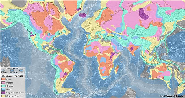
English: Map of world geologic provinces Foreland or intracratonic Basin Extended continental crust Age of Oceanic crust: 0–20 Ma 20–65 Ma >65 Ma Important note: These geologic province map renders only features approximately 150 km across and greater due to the fact that the resolution of the maps should be consistent with the resolution of the seismic refraction data. For example, the young uplifted blocks of the Variscan Orogen in Central and Western Europe such as the Rhenish Massif or the Massif Central are not depicted as ‘orogens’ but as part of the ‘extended continental crust’ in the western half of Europe.Deutsch: Karte der geologischen Provinzen der Erde. Vorland- oder „intrakratonisches“ Becken Gedehnte kontinentale Kruste Alter der ozeanischen Kruste: 0–20 Ma 20–65 Ma >65 Ma Hinweis: Diese Karte führt nur Einheiten, deren Ausbissfläche einen Durchmesser von mindestens 150 km besitzt. Beispielsweise sind die jung herausgehobenen Schollen des Variszischen Orogens in Mittel- und Westeuropa, wie z.B. die Rheinische Masse oder das französische Zentralmassiv, nicht als „phanerozoische Orogene“, sondern als Teil der „gedehnten kontinentalen Kruste“ in der Westhälfte Europas dargestellt.Ελληνικά: Παγκόσμιος Γεωλογικός Χάρτης
Ηπειρωτικές Λεκάνες
Μεγάλες πυριγενείς περιοχές
Εκτεταμένος ηπειρωτικός φλοιός
Ηλικία Ωκεάνιου φλοιού 0–20 Ma
20–65 Ma
>65 Ma <
Σημαντική σημείωση: Αυτός ο γεωλογικός χάρτης αποδίδει μόνο δομές μεγέθους 150 χλμ. και πάνω λόγω του ότι η ανάλυση των χαρτών πρέπει να είναι συνεπής με την ανάλυση των σεισμικών δεδομένων διάθλασης.Català: Mapa de les regions geològiques Conques d'avantpaís o intracratòniques Escorça continental extesa Edat de l' Escorça Oceànica: 0–20 Ma 20–65 Ma >65 Ma Nota important: Aquests mapes de regions geològiques només representen característiques d'aproximadament 150 km de diàmetre i més a causa del fet que la resolució dels mapes hauria de ser coherent amb la resolució de les dades de refracció sísmica. Per exemple, els blocs joves aixecats de l'Orogenia herciniana a l'Europa central i occidental, com el massís renà o el massís central, no es representen com a "orògens", sinó com a part de l'"escorça continental estesa" a la meitat occidental d'Europa. |
| Dată | original upload english wikipedia 22 April 2005 by SEWilco |
| Sursă | https://earthquake.usgs.gov/data/crust/maps.php archived version: https://web.archive.org/web/20150203073142/https://earthquake.usgs.gov/data/crust/maps.php |
| Autor | USGS |
| Alte versiuni |
Creații derivate din acest fișier: World geologic provinces North America cropped.png: |
Licențiere
This image is in the public domain in the United States because it only contains materials that originally came from the United States Geological Survey, an agency of the United States Department of the Interior. For more information, see the official USGS copyright policy.
|
Istoricul fișierului
Apăsați pe Data și ora pentru a vedea versiunea fișierului trimisă la momentul respectiv.
| Data și ora | Miniatură | Dimensiuni | Utilizator | Comentariu | |
|---|---|---|---|---|---|
| actuală | 3 enyatonai 2005 02:27 | | 1.200x637 (115 KB) | Saperaud~commonswiki | Map of world geologic provinces. Geologic provinces based on origin: * Shield * Platform (shield covered with sediment) * Orogen * Basin * Large igneous province * Extended [[Crust (geolog |
Chitroske phandimata
Următoarea pagină folosește acest fișier:
Utilizarea globală a fișierului
Următoarele alte proiecte wiki folosesc acest fișier:
- Utilizare la af.wikipedia.org
- Utilizare la anp.wikipedia.org
- Utilizare la ar.wikipedia.org
- Utilizare la ast.wikipedia.org
- Utilizare la be-tarask.wikipedia.org
- Utilizare la bg.wikipedia.org
- Utilizare la blk.wikipedia.org
- Utilizare la bn.wikipedia.org
- Utilizare la bs.wikipedia.org
- Utilizare la ca.wikipedia.org
- Utilizare la cs.wikipedia.org
- Utilizare la cv.wikipedia.org
- Utilizare la da.wikipedia.org
- Utilizare la de.wikipedia.org
- Utilizare la el.wikipedia.org
- Utilizare la en.wikipedia.org
Vizualizați utilizările globale ale acestui fișier.